Gorgeous Google map canvasses for your Drupal site: just Copy & Paste
Error message
- Deprecated function: Unparenthesized `a ? b : c ? d : e` is deprecated. Use either `(a ? b : c) ? d : e` or `a ? b : (c ? d : e)` in require_once() (line 10 of /home/flinkco/public_html/sites/all/modules/ip_geoloc/views/ip_geoloc_plugin_style_map.inc).
- Deprecated function: implode(): Passing glue string after array is deprecated. Swap the parameters in drupal_get_feeds() (line 394 of /home/flinkco/public_html/includes/common.inc).
I love maps.
I love gardens too.
Not keen on gardening, though.
So while the Google Maps API allows you to create beautiful map styles, that does not mean I enjoy spending hours or days doing that. Plus I don’t have the artistic prowess.
But the contributors to Snazzy Maps do. Snazzy Maps is a site full of gorgeous Google map canvasses, free for you to pick and match with the theme of your site.
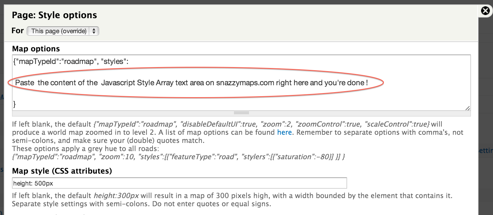
And here’s the clincher: to activate any of these super-stylish canvasses on your site, all you have to do is copy the Javascript style array from your favorite Snazzy map and paste it in the Map options box of the IP Geolocation Views & Maps module (v7.x-1.25 or later) map configuration panel (as shown in the screenshot below).
Beautiful maps without the gardening. Scroll down and smell the roses.
To import these beautiful canvasses into live maps on your Drupal site, use the IP Geolocation Views & Maps module. The maps below look particularly stunning on Retina displays.
Each map has been sprinkled with a number of markers at random locations, using the Geolocation Generator submodule that comes with IPGV&M. To use "real" data, you first create a View of content items that each have a latitude/longitude field or pair of fields. Then for the Format that the View will be rendered in, instead of Table or Unformatted List, choose Map (Google API, via IPGV&M). Click the Settings link and on the next panel drop the Javascript style array from your favorite Snazzy map into the Map options box. Easy. Just make sure you keep the first line in the screenshot and the closing bracket at the bottom.
Finally, choose an appropriate center & zoom option for your map.